|
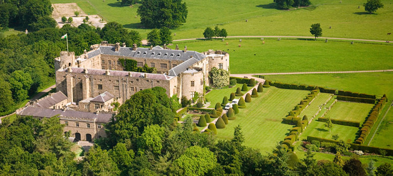
Chirk Castle © Crown copyright (2013) Visit Wales
The border
town of Chirk stands on the escarpment
above the point at which the rivers
Ceiriog and Dee meet. The name Chirk is
thought to be an English corruption of
the name 'Ceiriog', but we think it comes from the word 'Church' as the original Welsh name for the town was 'Eglwys-y-Waun' or 'Church on the Moor' (now shortened to Y Waun (The Moor)).
Chirk's strategic position gave rise to a motte and bailey castle built by the
Normans in the early 12th Century. In
1310, the Marcher fortress of
Chirk Castle, was
completed and today proudly guards the
entrance to the Ceiriog Valley.
  In the 19th
century vital road, rail and canal links
were developed. Chirk became a staging
post on the London to Holyhead mail road,
whilst the Llangollen branch of the
Shropshire Union Canal reached Chirk in
1801. The Llangollen canal is perhaps
Britain's most popular cruising canal and
Chirk Marina is well situated between
Thomas Telford's two magnicient
aqueducts at Chirk and at
Pontcysyllte. It is
possible to walk across both aqueducts if
you have a head for heights. Chirk
Aqueduct built between 1796 and 1801 by
Telford and William Jessop, is 70 feet
high with 10 arches. At the northern end
of the aqueduct, the canal enters Darkie
Tunnel which is wide enough for a single
barge and walkway. Using the walkway it
is possible to walk through the quarter
mile long tunnel. In the 19th
century vital road, rail and canal links
were developed. Chirk became a staging
post on the London to Holyhead mail road,
whilst the Llangollen branch of the
Shropshire Union Canal reached Chirk in
1801. The Llangollen canal is perhaps
Britain's most popular cruising canal and
Chirk Marina is well situated between
Thomas Telford's two magnicient
aqueducts at Chirk and at
Pontcysyllte. It is
possible to walk across both aqueducts if
you have a head for heights. Chirk
Aqueduct built between 1796 and 1801 by
Telford and William Jessop, is 70 feet
high with 10 arches. At the northern end
of the aqueduct, the canal enters Darkie
Tunnel which is wide enough for a single
barge and walkway. Using the walkway it
is possible to walk through the quarter
mile long tunnel.
The area's
main visitor attraction is
Chirk Castle. a
magnificient 700 year old marcher
fortress built by King Edward I. Owned by
the National Trust, the castle is open to
the public and has a shop and licenced
tea room. Chirk's railway station
established in 1846 by the Scottish
engineer Henry Robertson provides a
useful starting point for exploring
Chirk, Chirk Castle, Llangollen,
The Ceiriog Valley and the
surrounding areas.
The River
Ceiriog rises in the Berwyn Mountains at
1,800 feet and then swiftly, impetuously,
descends eastwards for some 18 miles to
confluence with the more sedate River
Dee. During it's length, the
Ceiriog Valley provides a
myriad of different landscapes and every
turn in the valley's meandering road
brings something new and unexpected. The
lush, pastoral valley floor 300 yards
across at its widest point, is home to
sheep and cattle; they quietly graze
beside the fast flowing, trout filled
waters of the Ceiriog. Further up the
valley, remote romantic rocky glens, and
wooded slopes are overlooked by bare
mountain summits and heather clad
moorland. Here, the overwhelming feeling
is of the impressiveness of the mountain
slopes and a sense of peacefulness. This
silence may only be broken by the call of
a buzzard or the bleating of a lamb.
|